In cities with very high buildings, the geolocation of our mobile device may fail. The signal from the satellites can bounce off the signals from the buildings and place us several meters away, or even on another street, from our actual location. Now if the blue dot of Google Maps shows you in the wrong position now you have a new way to calibrate your location.
The new update of Google Maps allows us calibrate our location through your mobile camera, making use of the recognition of the augmented reality of Live View.
Calibrate with Live View
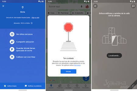
If we see that Google Maps is not situating us correctly, we can click on the blue dot and select the new option Calibrate with Live View to correct our position, as long as we have coverage and data.
When starting the calibration with Live View we will only have to focus buildings and posters from the street with the camera to tell us the location through Google image recognition. What Google does is compare the images that our camera shows with the Street View images of the area. Once the Google Maps process is completed, it will correctly place our location on the map.
This novelty is added to the improvements of the last days such as the improvement of Street View with information on places to the “augmented reality”, the integration with YouTube Music or its new navigation voice.

Maps – Navigation and public transport
Track | 9to5Google