Since de-escalation contributes to recovering the influx on public transport, Google has incorporated new security features in its mobile map application. From now on, you can check which lines report security risks, what is the forecast of crowds and you have the option of communicating the current influx of the transport in which you move.
There is no more useful and accessible application for getting around on public transport than Google Maps. Thanks to the fact that it comes pre-installed on most phones, and that the app communicates with the servers the user’s position and the time that elapses between the different stops, Maps allows to offer a multitude of relevant information for travel planning. Especially now that precautions have to be taken: Maps has introduced various changes to increase people’s safety.
Travel safer with Google Maps
Google Maps has evolved to become an endless compendium of information with everything related to travel. Both long-distance and those related to local routes: the real-time information offered by public transport networks is vital for a huge number of users. And now that there are many we return to the train, the bus or the subway to recover the old normality, it is very useful to know in advance the flow forecast.
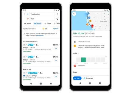
Given that social distancing is key to avoiding the spread of the coronavirus, and that during the peak hours it is very difficult to maintain this distancing, With Google Maps you can see if your journey is congested or not. Google has been introducing the information with the influx for some time, but now it is much more visible: just a glance to know if a transport line is full or not. And Google makes it easy to collaborate with Maps by sharing the flow information from the route screen.
Aside from the inflow information, Google Maps now shows the health alerts shared by the means of transport. If a line that you are going to travel shows any of these alerts, a warning icon will appear on the way; with the option of expanding the data if you click on it.
Finally, Google Maps has started to offer the influx data to the stations with the agglomerations forecast for each day of the week. In this way you can precisely plan the best time to move around, thus guaranteeing the maximum safety distance.
Google has begun to introduce the changes in its mobile application: these will gradually arrive in different countries, including Spain. AND you don’t have to update: Changes come from the server side.
More information | Google