Are you one of those who use Google Maps to plan bicycle trips? Well, navigation improves significantly in certain cities thanks to the introduction of rental services: from now on Maps can create routes taking into account the different anchorage stations.
Navigation started as a free way to use point-to-point GPS guidance. Included in Maps, this navigation set has always offered an excellent way to get around on private transportation. Not only that, it also includes everything you need to use public transport; along with another type of vehicle that usually takes advantage in cities: bikes. But how can cycling within cities be further optimized? Including the anchorage stations on the routes, those to which you must go to take or return a public bike. And Google has just introduced this option in Maps.
Plan bike routes including public stations

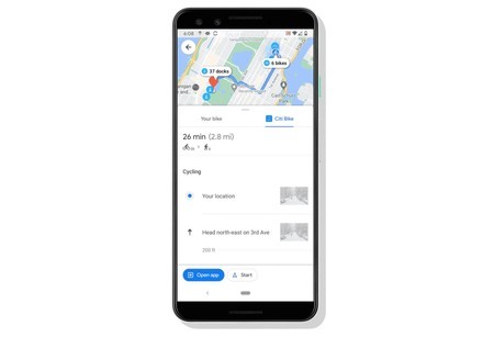
When planning a bike trip Google Maps used to take the starting point and the destination point so optimize the route without taking other values into account apart from distances or time. Now, and whenever the user is in one of the ten cities that start the pilot project, the routes will take into account the journey on foot to the closest anchorage, the bicycle route to the anchorage closest to the destination and, for last, the walk to the finish line. In this way the user can take advantage of public rental services saving on the way and without walking more than the bill.
The novelty is now available in the map application, although only in ten cities: Chicago, New York, the San Francisco Bay area, Washington DC, London, Mexico City, Montreal, Rio de Janeiro, São Paulo and Taipei (including New Taipei City). Information on cycling routes will include the bikes available at the anchorages and also photographs of the places where the different turns must be made. Everything to make the most of the journey taking into account the distance, the time, the bicycles available and the gaps near the destination.
As we said, the novelty is already available on Google Maps, although only for the indicated cities. It is hoped that it will gradually spread to more cities once the first tests are satisfactory.
More information | Google Maps


